Jump to content
Toggle menu
Toggle preferences menu
Toggle personal menu
Not logged in
Your IP address will be publicly visible if you make any edits.

Since 7 October 2026 every request to landrace.wiki passes through Cloudflare, a security service brought in after a denial-of-service attack made the site unreachable. The Privacy policy now explains what this means for your data.

Portal:Geography
Introduction

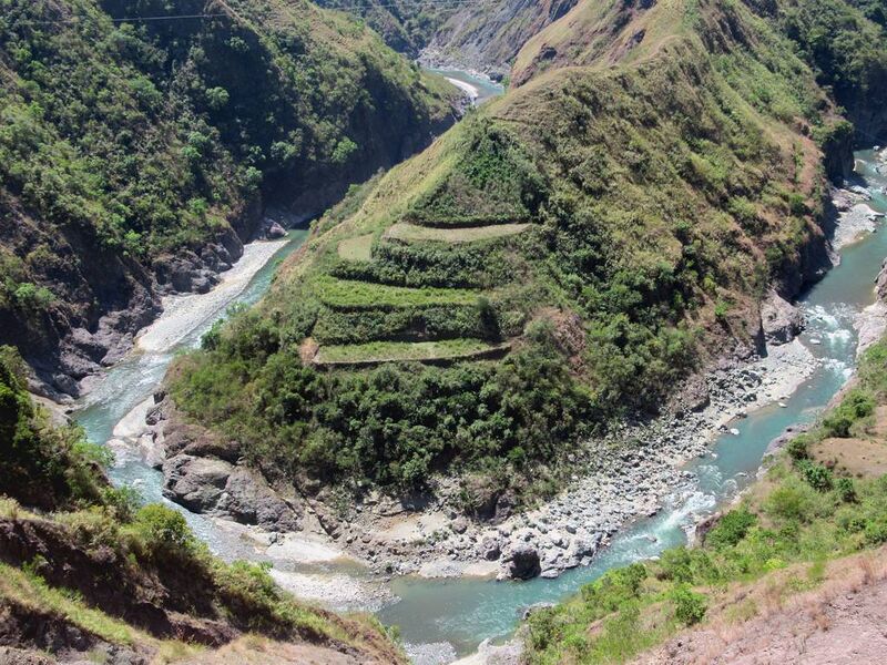
A green river curving through a rocky gorge around a steep hill, with terraced fields stepped into its upper slope.

Terraced slopes above the Chico River at Tinglayan, Kalinga, in the Cordillera of northern Luzon. Enforcement reports place cannabis plantations on Mount Chumanchil in this municipality (Philippines).

Cannabis geography covers where cannabis grows and is grown, and how place shapes the plant and its uses. This portal gathers the places the wiki documents: the countries, and within them the growing regions, growing areas, appellations and localities where landrace cannabis has been grown, collected and recorded.

Those places run from lowland plains to high valleys. The Terai of Nepal is a plain at roughly 60 to 330 metres above sea level, while the village of Malana, in the Malana Valley of the Western Himalayas, stands at about 2,740 metres. In Laos in the early 1970s the plant was grown in household gardens in the lowlands and along the Mekong, and for fibre by upland peoples on the high plateaus. In Northeastern Thailand it is documented from the Phu Phan range, a narrow belt of sandstone hills across the middle of the Khorat Plateau. In Kenya it is grown illegally in the Lake Victoria basin, in the central highlands around Mount Kenya and along the coast.

Places are arranged on a ladder that runs from country to growing region, growing area, appellation and locality; states, provinces and districts form a separate administrative layer. Each level has its own browse page, and each regional portal gathers the places of one part of the world.

Featured article
Did you know...
  • ...that the Kangra gazetteers of 1897 and 1917 described the heavy rain on the Jalori ridge as fatal to the resin of the hemp grown there but good for its fibre, which villagers made into rope and grass shoes?
  • ...that in the 1890s the Nepal Darbar told the Indian Hemp Drugs Commission that cannabis grew wild throughout Nepal, and more abundantly in the Terai than in the hills?
  • ...that from the late 1960s into the 1980s Northeastern Thailand held the country's main cannabis fields, and that its seedless flower became known abroad as Thai stick?
  • ...that estimates of the wild cannabis in the Shu Valley of Kazakhstan run from 62,000 hectares to as much as 400,000 hectares?
  • ...that in the 17th century the valleys of Quillota and La Ligua in Chile grew hemp for the rigging of Pacific ships and for the army's cord?
  • ...that most of the cannabis grown in Eswatini comes from the steep, hilly north of the country?
Selected picture

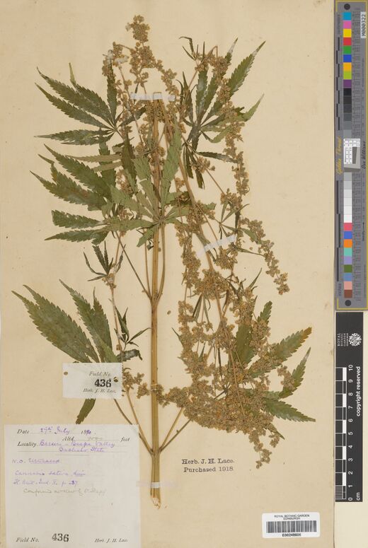
A pressed cannabis plant with palmate leaves and branching flowering stems mounted on a herbarium sheet, with field labels and a colour scale.

One of three sheets of J. H. Lace's number 436, collected at Barseri in the Baspa valley, Bashahr State, at 9,000 feet on 27 July 1890 (Lace 436 (1890), Royal Botanic Garden Edinburgh).
The geographic ladder
Countries
Browse by country · 69 pages
Growing regions
Browse by growing region · 87 pages
Growing areas
Browse by growing area · 226 pages
Appellations
Browse by appellation · 86 pages
Localities
10 pages
Administrative subdivisions
States, provinces and districts: 28 pages
Elevation and map
Browse by elevation · Browse by map
Major topics
Overview
Cannabis geography · Landrace cannabis
Gene Pool Regions
Gene pool · Centre of origin
Regional Complexes
Hindu Kush Himalaya · Mekong Basin · Khorat Plateau · Ganges Basin
Altitude Zones
Altitudinal zonation
Topography and Terrain
Himalayas · Western Ghats · Deccan Plateau · Atlas Mountains · Andes · Kravanh Mountains · Damrei Mountains · Bayong Kor Range · Pin Parvati Pass · Rasol Pass · Riparian zone
Biogeographic Patterns
Native range · Feral and ruderal Cannabis
Environmental Gradients
Terroir in Cannabis
Cultivation Zones
Aegean Region (Turkey) · Altai Krai (growing region) · Amur basin · Black Sea Region (Turkey) · Brahmaputra Valley · Brong Ahafo · Casamance · Central Afghanistan · Central Himalayas · Central Laos · Central Myanmar · Central Thailand · Cordillera Central · Cordillera Central (Colombia) · Eastern Afghanistan · Eastern Ghats · Eastern Himalayas · Eastern Mongolia · Eastern Terai · Eastern Thailand · Fergana Valley · Garhjat · Hindu Kush · Indo-Burman Range · Ishim steppe · Kachin Hills · Karakoram · Kham · Kohistan (Khyber Pakhtunkhwa) · Krasnoyarsk Krai (growing region) · Kurgan Oblast (growing region) · Lake Victoria basin · Malanje · Maloti Mountains · Malwa · Midwestern United States · Minusinsk Basin · Morogoro · Moyynkum · New Guinea Highlands · Nimar · North Avadh · North Bengal Plains · North Bihar Plains · North-eastern Afghanistan · Northeast China · Northeastern Thailand · Northern Afghanistan · Northern Colombia · Northern Laos · Terraced cultivation
Geographic Navigation
Regional complex · Growing region · Growing area · Appellation
Climate Zones
Tropical climate · Tropical rainforest climate · Tropical monsoon climate · Subtropical climate · Mediterranean climate · Temperate climate · Continental climate · Oceanic climate · Desert climate · Semi-arid climate · Montane climate
Climate Systems
Monsoon · Orographic lift · Rain shadow · Photoperiod
Things you can do
Help improve geography articles
  • Write the ladder's own terms: Hindu Kush Himalaya and Appellation, the most-linked geography pages still to be written
  • Write the landforms the articles name: the Himalayas, the Khorat Plateau, the Western Ghats and the Mekong Basin
  • Write the missing country pages: Taiwan, Malaysia, Mozambique and Zimbabwe are named by accessions but have no page yet
  • Place accessions on the map: give a herbarium sheet or a seed-bank line a point at the settlement, district or valley its label or listing names, never at a field, and say on its Talk page which place the point stands for
  • Fill elevation and rainfall: add the ranges to growing region and growing area pages from published sources
  • Photograph places: landscapes of the growing regions and growing areas that have no picture yet
  • Record local names: place names in the languages spoken there, with the source that gives them
Browse places
Growing area
Laos · Champasak Province · Southern Laos
Elevation 78 m
Administrative subdivision
Indonesia
Growing area
Russia · Krasnoyarsk Krai · Krasnoyarsk Krai (growing region)
Growing region
Turkey · İzmir, Manisa
Country
West Asia
Growing area
Ghana · Eastern Region (Ghana)
Growing area
India · Maharashtra
Growing area
China · Xinjiang · Southern Xinjiang
Country
North Africa
Growing area
India · West Bengal · The Dooars
Growing region
Russia · Altai Krai
Growing region
Russia · Khabarovsk Krai, Primorsky Krai
Growing area
Madagascar · Diana Region
Country
Central Africa
Growing area
India · Odisha · Garhjat
Growing area
India · Madhya Pradesh
Growing area
India · Andhra Pradesh · Eastern Ghats
Growing area
Greece · Peloponnese
Growing area
Colombia · Meta Department
Country
West Asia
Growing area
China · Xinjiang · Southern Xinjiang
Administrative subdivision
India
Appellation
India · Himachal Pradesh · Western Himalayas
Elevation 2,631 m – 3,700 m
Growing area
India · Kerala · Western Ghats