Toggle menu
83
56
34
2.9K
Landrace.Wiki - The Landrace Cannabis Wiki
Toggle preferences menu
Toggle personal menu
Not logged in
Your IP address will be publicly visible if you make any edits.

Portal:Geography

From Landrace.Wiki - The Landrace Cannabis Wiki
Revision as of 13:32, 20 January 2026 by Eloise Zomia (talk | contribs) (Created page with "<templatestyles src="Template:LWPortal/styles.css" /> <div class="lw-portal"> <div class="lw-portal__title">Portal:Geography</div> <div class="lw-portal__bar"> <span><b>Browse:</b></span> <span>Botany</span> <span>·</span> <span>Genetics</span> <span>·</span> <span>Cultivation</span> <span>·</span> <span>Ethnobotany</span> <span>·</span> <span>Conservation</s...")
(diff) ← Older revision | Latest revision (diff) | Newer revision → (diff)
Portal:Geography
Introduction

File:Cannabis-geographic-distribution-map.jpg

Global distribution of landrace cannabis populations across climate zones and altitude gradients

Cannabis geography examines the spatial distribution of landrace populations, environmental contexts of cultivation zones, and geographic patterns of diversity across Asia, Africa, and the Americas. Geography provides the organizing framework for understanding where traditional varieties grow, why they grow there, and how environmental factors shape regional characteristics.

Landrace cannabis cultivation spans an extraordinary range of environments—from equatorial lowlands receiving year-round rainfall to high Himalayan valleys where frost dictates short growing seasons, from Mediterranean climates with dry summers to monsoon-dominated regions with distinct wet and dry seasons. This geographic diversity reflects both the species' remarkable ecological amplitude and millennia of human-mediated dispersal and adaptation.

The geographic organization of landrace populations follows a hierarchical structure from broad gene pools (Southeast Asia, South Asia, Central Asia, Africa, Americas) through regional complexes (Mekong Basin, Hindu Kush-Himalayan) to specific Growing Regions, Growing Areas, Appellations, and individual Fields where accessions are collected. Understanding this geographic framework is essential for navigating the diversity of traditional cannabis, documenting regional variation, and organizing conservation priorities.

Featured article

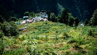
The Hindu Kush-Himalayan regional complex represents one of the world's most important centers of landrace cannabis diversity, spanning Afghanistan, Pakistan, India, Nepal, and Bhutan. This massive mountain system creates extreme environmental gradients from subtropical river valleys below 1000m to high-altitude cultivation zones exceeding 3500m elevation, driving extraordinary morphological and chemical diversification in local populations.

The complex includes major growing regions like the Western Himalayas (Parvati Valley, Kullu Valley), Kashmir Valley, Chitral, and numerous valleys throughout the Hindu Kush where traditional charas production has occurred for centuries. Altitude-driven environmental variation creates distinct ecotypes—lowland populations with longer flowering times and taller stature versus compact, early-flowering highland types adapted to short growing seasons and intense UV radiation. The orographic effect of these mountains creates dramatic rainfall gradients, with windward slopes receiving abundant monsoon moisture while leeward rain-shadow zones remain arid, further diversifying cultivation environments and traditional varieties.

(Full article...)

Did you know...
  • ...that cannabis is cultivated across an altitude range exceeding 3500 meters, from sea-level river deltas to high Himalayan valleys where frost limits growing seasons to 3-4 months?
  • ...that the Mekong Basin supports traditional cultivation across five countries, with regional populations adapted to distinct monsoon timing and flooding patterns?
  • ...that cannabis grows naturally across tropical, subtropical, temperate, and montane climate zones, making it one of the most environmentally versatile cultivated plants?
  • ...that latitude determines photoperiod patterns, with equatorial populations flowering year-round while temperate varieties show strict seasonal responses?
  • ...that the rain shadow effect in mountain regions creates dramatically different environments on opposite sides of ranges, driving local adaptation in cannabis populations?
  • ...that traditional cultivation zones often coincide with remote mountain regions where difficult access has protected populations from eradication and genetic pollution?
Selected picture
Cannabis cultivation altitude zones from tropical lowlands (0-500m) through highland valleys (1500-2500m) to high mountain zones (2500-3500m+), showing temperature and UV gradients
Major topics
Gene Pool Regions
Southeast Asia · South Asia · Central Asia · Africa · Americas · Thailand · India · Nepal · Afghanistan · Morocco · Mexico · Colombia
Climate Zones
Tropical climate · Tropical wet · Tropical monsoon · Subtropical climate · Mediterranean climate · Temperate climate · Continental climate · Arid zones · Semi-arid zones · Montane climate
Altitude Zones
Lowland zones · Lowland tropics · Mid-elevation zones · Highland zones · High mountain zones · Altitude effects · Temperature gradients · UV radiation gradients · Growing season length
Regional Complexes
Hindu Kush-Himalayan · Mekong Basin · Ganges Basin · Western Ghats · Atlas Mountains · Andes · Khorat Plateau · Deccan Plateau
Climate Systems
Asian monsoon · Summer monsoon · Winter monsoon · Monsoon agriculture · Maritime climate · Continental climate systems · Orographic effects · Rain shadow · Windward slopes · Leeward slopes
Topography & Terrain
Mountain cultivation · Valley cultivation · Plateau cultivation · Hillside cultivation · Terraced slopes · Slope gradients · Aspect effects · Watershed cultivation · Riparian zones
Biogeographic Patterns
Geographic distribution · Native range · Cultivation zones · Wild populations · Feral populations · Latitude patterns · Photoperiod gradients · Dispersal patterns · Trade routes
Environmental Gradients
Altitudinal gradients · Vegetation zones · Latitudinal gradients · Seasonal variation · Moisture gradients · Rainfall gradients · Wet-dry transitions
Cultivation Zones
Traditional cultivation zones · Major growing regions · Historical cultivation areas · Valley cultivation systems · Mid-slope cultivation · Highland cultivation systems · Terrace systems
Geographic Navigation
Geographic hierarchy · Gene Pool · Regional Complex · Growing Region · Growing Area · Appellation · Field · Browse by region · Browse by altitude · Map-based browsing
Things you can do
Help improve geography articles
  • Document locations: Add GPS coordinates and elevation data for cultivation sites
  • Map growing regions: Contribute to mapping traditional cultivation zones
  • Describe climate: Record local climate patterns, rainfall, temperature ranges
  • Photograph landscapes: Share habitat photos showing topography and environment
  • Record local names: Document traditional place names and geographic terminology
  • Expand stubs: Orographic effects, Altitude effects, Regional complexes
Regional portals
Categories