Northeastern Thailand: Difference between revisions
From Landrace.Wiki - The Landrace Cannabis Wiki
More actions
Eloise Zomia (talk | contribs) No edit summary |
Eloise Zomia (talk | contribs) No edit summary |
||
| Line 3: | Line 3: | ||
|other_name = Isaan, Isarn, Issarn, Issan, Esan, or Esarn | |other_name = Isaan, Isarn, Issarn, Issan, Esan, or Esarn | ||
|image = Phu-Phan-Mountains-01.jpg | |image = Phu-Phan-Mountains-01.jpg | ||
|image_caption = Looking towards the Phu Phan mountains over the rice fields | |image_caption = Looking towards the Phu Phan mountains over the rice fields, Sakhon Nakhon Province, Thailand, December 2025 | ||
|show_map = yes | |show_map = yes | ||
|gene_pool = Lao-Isan Genepool | |gene_pool = Lao-Isan Genepool | ||
|regional_complex = | |regional_complex = Khorat Plateau | ||
|country = | |country = Thailand | ||
|provinces = | |provinces = Nakhon Phanom, Sakhon Nakhon, Nong Khai, Mukdahan, Loei, Udon Thani, Nakhon Ratchasima, Buriram, Surin, Yasothon, Roi Et | ||
|elevation_range = 150–1,300 m (492–4,265 ft) | |elevation_range = 150–1,300 m (492–4,265 ft) | ||
|climate = Tropical savanna (Köppen: Aw), semi-arid zones | |climate = Tropical savanna (Köppen: Aw), semi-arid zones | ||
|primary_river = | |primary_river = Mekong, Mun, Chi | ||
|primary_mountains = | |primary_mountains = Phu Phan Mountains, Phetchabun Mountains, Dong Phaya Yen Mountains, Sankamphaeng Range | ||
|area_extent = 167,718 | |area_extent = 167,718 km² | ||
|status = Endangered | |status = Endangered | ||
|coordinates = | |coordinates = 16.000000, 103.000000 | ||
|description = Khorat Plateau cultivation zone shaped by Mekong tributaries, monsoonal rice agriculture, and long-standing Lao-Isan cultural continuity | |||
}} | }} | ||
'''Northeastern Thailand''' (often called '''Isaan''') is a cultivation region centered on the [[Khorat Plateau]] and its surrounding uplands. Cannabis persists across river corridors, rice-growing lowlands, and upland margins where elevation, water access, and local agrarian cycles structure planting and selection. | |||
== | == Geography == | ||
== | == Climate == | ||
== | == Demography == | ||
==Cultivation History== | == Culture == | ||
== Cultivation History == | |||
== Genetics == | == Genetics == | ||
No data at present, further research needed. | |||
No | == Growing Areas == | ||
{{#ask: | |||
[[Category:Growing Areas]] | |||
[[Has growing region::{{PAGENAME}}]] | |||
|mainlabel=Growing Area | |||
|format=table | |||
|default=No growing areas documented yet. | |||
}} | |||
== | == Accessions == | ||
{{#ask: | |||
[[Category:Accessions]] | |||
[[Has growing region::{{PAGENAME}}]] | |||
=== | |?Has descriptive name=Name | ||
|?Has conservation priority=Priority | |||
|?Has collection date=Collected | |||
|?Has locality=Locality | |||
|mainlabel=Accession ID | |||
|format=table | |||
|class=wikitable sortable | |||
|sort=Has collection date | |||
|order=desc | |||
|default=No accessions documented yet. | |||
}} | |||
== | == Botanical Characteristics == | ||
=== Regional Traits === | |||
=== Geographic Variation === | |||
=== | == Cultivation Practices == | ||
=== Traditional Methods === | |||
=== Modern Methods === | |||
===Conservation Efforts=== | == Conservation Status == | ||
=== Threats to Landrace Populations === | |||
=== Conservation Efforts === | |||
==Chemical Profile== | == Chemical Profile == | ||
=== Cannabinoid Content === | |||
===Cannabinoid Content= | |||
== Gallery == | |||
<gallery mode="packed" heights="200px"> | <gallery mode="packed" heights="200px"> | ||
File:Phu-Phan-Mountains-01.jpg|Looking towards the Phu Phan mountains over the rice fields | File:Phu-Phan-Mountains-01.jpg|Looking towards the Phu Phan mountains over the rice fields, Sakhon Nakhon Province, Thailand, December 2025 | ||
</gallery> | |||
== See Also == | |||
==See Also== | |||
* [[Gene pools]] | * [[Gene pools]] | ||
* [[Lao-Isan Gene Pool]] | * [[Lao-Isan Gene Pool]] | ||
* [[Growing regions]] | * [[Growing regions]] | ||
* [[ | * [[Thailand]] | ||
==References== | == References == | ||
{{Reflist}} | {{Reflist}} | ||
[[Category:Southeast Asian Growing Regions]] | [[Category:Southeast Asian Growing Regions]] | ||
Revision as of 00:02, 20 January 2026
| Northeastern Thailand | |
|---|---|
| Isaan, Isarn, Issarn, Issan, Esan, or Esarn | |

| |
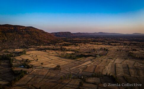
| Looking towards the Phu Phan mountains over the rice fields, Sakhon Nakhon Province, Thailand, December 2025 | |
| Location | |
| Coordinates | 16.000000, 103.000000 |
| Gene Pool | Lao-Isan Genepool |
| Regional Complex | Khorat Plateau |
| Country | Thailand |
| Provinces/States | Nakhon Phanom,Sakhon Nakhon,Nong Khai,Mukdahan,Loei,Udon Thani,Nakhon Ratchasima,Buriram,Surin,Yasothon,Roi Et |
| Elevation Range | 150–1,300 m (492–4,265 ft) |
| Area | 167,718 km² |
| Climate | Tropical savanna (Köppen: Aw), semi-arid zones |
| Primary Rivers | Mekong,Mun,Chi |
| Primary Mountains | Phu Phan Mountains,Phetchabun Mountains,Dong Phaya Yen Mountains,Sankamphaeng Range |
| Conservation Status | Endangered |
Northeastern Thailand (often called Isaan) is a cultivation region centered on the Khorat Plateau and its surrounding uplands. Cannabis persists across river corridors, rice-growing lowlands, and upland margins where elevation, water access, and local agrarian cycles structure planting and selection.
Geography
Climate
Demography
Culture
Cultivation History
Genetics
No data at present, further research needed.
Growing Areas
No growing areas documented yet.
Accessions
| Accession ID | Name | Priority | Collected | Locality |
|---|---|---|---|---|
| ZOM-THA-PHU-0220250001 | Krabangkham 'Squirrel Tail' Selection 2024 | Critical | 26 February 2025 | Ban Nan Toeng |
| ZOM-THA-ISA-0220250001 | Nakhon Phanom 'Squirrel Tail' Selection 2023 | High | 15 February 2025 | |
| ZOM-THA-ISA-0220250002 | Dong Luang 'Tiger Tail' Selection 2024 | High | 15 February 2025 | |
| ZOM-THA-PHU-0120250001 | Ta Lo Farm Squirrel Tail Selection 2024 | Medium | 26 January 2025 | Ta Lo Farm |
| ZOM-THA-PHU-0120250005 | Khun Aek Farm 'Tiger Tail' Selection 2024 | Medium | 26 January 2025 | Ban Nan Toeng |
| ZOM-THA-PHU-0120250003 | Ta Lo Farm Foytong Selection 2024 | Medium | 26 January 2025 | Ban Bua |
| ZOM-THA-PHU-0120250004 | Khun Aek Farm General Population 2024 | Medium | 26 January 2025 | Ban Nan Toeng |
| ZOM-THA-PHU-1220240005 | Ban Bua General Population 2024 | High | 10 January 2025 | Ban Bua |
| ZOM-THA-PHU-1220240003 | Ban Bua 'Tiger Tail' Selection 2024 | High | 10 January 2025 | Ban Bua |
| ZOM-THA-PHU-1220240004 | Ban Bua 'Squirrel Tail' Selection 2024 | High | 10 January 2025 | Ban Bua |
| ZOM-THA-NKP-0320250001 | Phiman 'Mango Tail' IBL General Population 2025 | High | 2025 | Phiman |
| ZOM-THA-PHU-1120240011 | Ban Nan Toeng 'Purple' Selection 2024 | High | 18 November 2024 | Ban Nan Toeng |
| ZOM-THA-PHU-1120240008 | Ban Nan Toeng 'Elite' Selection #6 2024 | High | 18 November 2024 | Ban Nan Toeng |
| ZOM-THA-PHU-1120240007 | Ban Nan Toeng 'Elite' Selection #5 2024 | High | 18 November 2024 | Ban Nan Toeng |
| ZOM-THA-PHU-1120240005 | Ban Nan Toeng 'Elite' Selection #3 2024 | High | 18 November 2024 | Ban Nan Toeng |
| ZOM-THA-PHU-1120240010 | Ban Nan Toeng 'Elite' Selection #8 2024 | High | 18 November 2024 | Ban Nan Toeng |
| ZOM-THA-PHU-1120240003 | Ban Nan Toeng 'Elite' Selection #1 2024 | High | 17 November 2024 | Ban Nan Toeng |
| ZOM-THA-PHU-1120240004 | Ban Nan Toeng 'Elite' Selection #2 2024 | High | 17 November 2024 | Ban Nan Toeng |
| ZOM-THA-PHU-1120240001 | Ban Nan Toeng 'The Boys' Selection 2024 | High | 17 November 2024 | Ban Nan Toeng |
| ZOM-THA-PHU-1120240002 | Ban Nan Toeng General Population 2024 | High | 17 November 2024 | Ban Nan Toeng |
| ZOM-THA-PHU-0420240002 | Krabangkham 'Squirrel Tail' Selection 2023 | Critical | 26 April 2024 | Ban Nan Toeng |
| ZOM-THA-PHU-0420240005 | Ban Nan Toeng General Population 2023 | High | 26 April 2024 | Ban Nan Toeng |
| ZOM-THA-NKP-0420240006 | Tanaosri 'White' General Population 2023 | High | 26 April 2024 | That Phanom |
| ZOM-THA-NKP-0420240003 | Si Songkhram ‘Nong Sarai’ General Population 2024 | High | 26 April 2024 | Nong Sarai |
| ZOM-THA-NKP-0420240011 | NKPB 'Thai Stick' General Population 2023 | High | 26 April 2024 | Muang Nakhon Phanom |
| ZOM-THA-PHU-0420240006 | Nam Phung 'Squirrel Tail' Selection 2024 | High | 26 April 2024 | Nam Phung |
| ZOM-THA-NKP-0420240007 | Suranaree University 'Squirrel Tail' General Population 2023 | High | 26 April 2024 | That Phanom |
| ZOM-THA-PHU-0420240001 | Krabangkham General Population 2023 | Medium | 26 April 2024 | Ban Nan Toeng |
| ZOM-THA-PHU-0420240007 | Kok Phu 'Squirrel Tail' Selection 2024 | High | 26 April 2024 | Kok Phu |
| ZOM-THA-NKP-0420240008 | Suranaree University 'Tiger Tail' General Population 2023 | High | 26 April 2024 | That Phanom |
| ZOM-THA-PHU-0420240008 | Kok Do 'Squirrel Tail' Selection 2024 | High | 26 April 2024 | Kok Do |
| ZOM-THA-NKP-0420240001 | Si Songkhram ‘Kham Hai’ General Population 2024 | High | 26 April 2024 | Tha Kham Hai |
| ZOM-THA-NKP-0420240009 | NKPB 'Erawan' General Population 2023 | High | 26 April 2024 | Muang Nakhon Phanom |
| ZOM-THA-PHU-0420240003 | Krabangkham Farm 'Tiger Tail' Selection 2023 | Medium | 26 April 2024 | Ban Nan Toeng |
| ZOM-THA-PHU-0420240004 | Krabangkham 'Suriyan's' Selection 2023 | High | 26 April 2024 | Ban Nan Toeng |
| ZOM-THA-NKP-0420240005 | Thai Issara 'Freedom' General Population 2023 | High | 26 April 2024 | That Phanom |
| ZOM-THA-NKP-0420240002 | Si Songkhram ‘Tha Bo’ General Population 2024 | High | 26 April 2024 | Tha Bo |
| ZOM-THA-NKP-0420240010 | NKPB 'Skunk' General Population 2023 | High | 26 April 2024 | Muang Nakhon Phanom |
| ZOM-THA-NKP-0420240004 | Si Songkhram ‘Don Toei’ General Population 2024 | High | 26 April 2024 | Don Toei |
| ZOM-THA-PHU-0320250001 | Khun Aek Farm 'Squirrel Tail' Selection 2024 | High | 5 March 2024 | Ban Nan Toeng |
| ZOM-THA-PHU-0320250002 | Ban Nan Toeng 'Mama Somchai' General Population 2024 | High | 5 March 2024 | Khok Phu |
| ZOM-THA-PHU-0220250002 | Krabangkham Farm 'Tiger Tail' Selection 2024 | Medium | 5 March 2024 | Ban Nan Toeng |
| ZOM-THA-PHU-0220250003 | Krabangkham Farm 'Suriyan’s' Selection 2024 | Medium | 26 February 2024 | Ban Nan Toeng |
| ZOM-THA-NKP-0220250001 | Si Songkhram 'Khun Seri' General Population 2024 | High | 23 February 2024 | Don Haet |
| ZOM-THA-NKP-0220250003 | Si Songkhram 'Tiampon' General Population 2024 | High | 23 February 2024 | Various villages |
| ZOM-THA-PHU-1220240001 | Lin Pooh General Population 2024 | High | 12 January 2024 | Ban Nan Toeng |
| ZOM-THA-PHU-1220240002 | Ta Lo General Population 2024 | High | 12 January 2024 | Ban Bua, Impang |
| ZOM-THA-PHU-1120240012 | Krabangkham Farm General Population 2024 | Medium | 2024 | Ban Nan Toeng |
| ZOM-THA-NPK-0220250004 | Ban Phaeng General Population 2024 | High | 2024 | Various villages |
| ZOM-THA-NKP-0220250002 | Wang Yang 'Jen Jen Selection' General Population 2024 | Medium | 2024 | Wang Yang |
| ... further results | ||||
Botanical Characteristics
Regional Traits
Geographic Variation
Cultivation Practices
Traditional Methods
Modern Methods
Conservation Status
Threats to Landrace Populations
Conservation Efforts
Chemical Profile
Cannabinoid Content
Gallery
-
 Looking towards the Phu Phan mountains over the rice fields, Sakhon Nakhon Province, Thailand, December 2025